Over three thousand kilometers drive through one of the most unique places on Earth

Namibia, was, for both of us, a really unique experience and one of the best trips we ever had. We are not sure if it was purely the country, the idea of a road trip or maybe the camping part, but we absolutely loved it!
For those who don`t already know, Namibia is a pretty big country in southern Africa which is bordered by Angola to the north, Botswana and Zambia to the East and South Africa in south-east. It is rather dry and arid, hosting two deserts: Namib and Kalahari. Therefore, it`s population is low – only 2 million inhabitants – making it the second least densely populated country in the world.
Also, speaking of Namib, did you know that the country gets its name from this desert?
Namibia used to be a German colony, then was captured by South Africa in WW I and this can be felt throughout the country.
Some other interesting facts?
Namibia is the first country in the world to incorporate environmental protection into it`s Constitution.
The country is home to the world`s largest population of free roaming cheetahs and free roaming black-rhinos and one of the only two countries in the world that has desert elephants ( the other one is Mali ).
It is also home to the largest sand dunes in the world and to the oldest desert.
Getting there
There are not too many airlines flying to Windhoek and you will most probably need to make a stop over. We used Qatar Airways and went there via Doha and Johannesburg. Some of the other airlines that fly there are: KLM, Air Namibia, British Airways, South African, Lufthansa, Ethiopian.
Be careful, though, and check if you need transit visa in any of the stop over destinations, especially in South Africa.
Do you need a visa ?
Well, it depends. As Romanians, we thought that we needed a visa and therefore we applied for one a month before. However, it turns out that recently, they introduced visa on arrival in Windhoek and Romanians can pay for their visa on the spot. I double checked with Immigration in Windhoek airport and they confirmed. Make sure you have a 6 month validity passport with one blank page ( valid from the date of entry ) a return ticket, booked accommodation and cash to pay for the visa.
For other nationalities we cannot tell for sure but most of the EU countries, Canada, US, Australia, New Zealand are either visa free or can obtain visa on arrival. However, check it with your own Ministry of Foreign Affairs or Namibia Embassy.
When to go
In general Namibia’s climate can be described as hot and dry.
With an average of 300 days of sunshine annually Namibia is one of the sunniest countries in worldwide. The climate is generally arid which means that the potential evaporation is higher than the precipitation, which again results in a very low humidity.
However, on the coast, due to the cold Benguela current, the climate is pretty cold, with an average of 15-20 °C throughout the year.
Namibia has two seasons, summer ( November to April ) also known as the rainy season and winter ( May to October ) also known as the dry season.
That being said, Namibia can be visited throughout the year. The climate is generally dry and pleasant. Between December and March, some days will be humid and rain may follow, often in localized, afternoon thunderstorms. Wildlife viewing in all parks, but especially in Etosha, is best in the Dry season from June to October. In the Wet season, animals move away from the waterholes and scatter around the park.
We went there in mid November and the weather was very dry and sunny and the temperature was around 30 – 35 °C during the day and slightly cold during the night ( 20 – 22°C ). On the coast was pretty chilly, though.

How much time you need?
We were wondering the same thing and, after having looked at the size of the country, we got the wrong impression that we will need at least 2-3 weeks for a road trip over there.
In reality, despite the huge distances, the roads are empty and you can easily drive an average of 100 – 110 km/ h, therefore, depending on how much you want to visit, 7 -10 days would be enough.
We had 9 full days and 2 half days and we must say that it was perfect. We managed to do everything we had in mind and we didn`t feel the need to stay more in one place. However, if you don`t want to be on the road all the time, we advise on booking 13-14 days.
( We will detail our road trip a bit later )
Vaccination and medication
A yellow fever vaccination certificate is required for people visiting Namibia from countries with a risk of yellow fever transmission.
It’s recommended that you get vaccinations for cholera, typhoid, tetanus, hepatitis A and B, and diphtheria. The rabies vaccination is recommended if you’re going to be staying in remote areas where you may not have medical access for an emergency vaccination, if you’re going for a particularly long trip, or if you’re going to have a higher risk of contact with animals and bats.
From November to June there is a high risk of malaria in the Ohangwena, Omaheke, Omusati, Oshana, Oshikoto and Otjozondjupa regions and a medium risk in northern Namibia, such as in Etosha National Park and the Zambezi Region. That is, pretty much, the northern half of the country.
In all other areas there is a low to no risk of malaria throughout the year. To prevent mosquito bites, use DEET 40% or 50% repellent on your skin and clothes, wear long trousers and shirts in the early morning and evenings and, if possible, sleep under a mosquito net.
However, these are the general rules but the risk is not that high compared to central Africa. We didn`t stress too much about it.
We had all the vaccines done from our previous trips ( the vaccines have 5 or 10 years validity! ) and we tried to avoid mosquito bites using DEET repellent. We had Coartem with us, a treatment for malaria, for the worst case scenario. We also considered buying some malaria self tests but we didn’t, in the end. Malaria self tests can be either purchased online or in some pharmacies in Namibia.
Getting around
Definitely rent a car! Namibia is the perfect country for road trips, therefore, not having your own car will make you miss all the fun.
Although is still possible to get around some places in a small car, we highly advise to rent a 4×4.
Most of the roads are not tarred and full of dust, rocks and occasionally sand, therefore a 4×4 will keep you out of trouble. The big cars also have double tanks, which is very handy when there is no gas station for 400 km.
More info on the roads condition and driving in Namibia can be found here.
We rented a Toyota Hilux 4×4 camper version ( tent on top, camping gear, fridge ) and we absolutely loved it. We`ve heard some bad stories about some rental companies but the company we used was very nice and the car worked just fine for over 3000 km. Somebody else has recommended Savanna Car hire to us and now we can also recommend it to you.
Bear in mind, due to the fact that the car has a lot of camping gear, you`ll need a thorough briefing on how to use it, which will take 1h 1/2 – 2 hrs, so, plan accordingly.

Where to go
Most of the people come here for the famous Deadvlei / Sossusvlei but Namibia is so much more than that. Visiting a Himba village, going on a safari in Etosha National Park, seeing the Namib desert dunes entering the Atlantic ocean at Sandwich Harbour, visiting Kolmanskop ghost town, seeing the wild horses near Aus, enjoying how landscape changes in Damaraland or simply enjoying the drive and camping through one of the most un-populated countries in the world are all incredible things!
Some other places we haven`t been to are: Fish River canyon, Spitzkoppe, Cape Cross Seal Reserve, Skeleton Coast and Quiver tree forest.
Also, if you have some extra time, there is a Cheetah Farm in between Kamanjab and Etosha which should be worth visiting.
So, in summary:
1. Deadvlei/ Sossusvlei + Dune 45 + Sesriem canyon
2. Etosha National park
3. Himba village
4. Swakopmund, Walvis Bay + Sandwich Harbour + Cape Cross seal colony
5. Kolmanskop + Luderitz
6. wild horses in Aus ( on the way to Luderitz )
7. Damaraland + Spitzkoppe
8. Skeleton Coast
9. Fish river canyon
10. Quiver tree forest
Our 10 days road trip
As mentioned before, we had 9 full days and 2 half days and our start and finish point was Windhoek. Since the time was pretty tight for such a huge country we tried to squeeze in everything and in some places we didn`t get too much time but we still enjoyed everything.
Although we had the tent, we didn`t spend all the nights in it because in some places was too cold over the night ( on the coast ), in other places we couldn`t find a private place in a camping and for the first night we just wanted to get a warm shower after traveling for 24 hrs to Namibia. In the end, we spent about 5 nights on the tent and the rest of 5 nights in various accommodation.
On the map, our road trip looked like this:

Day 1 – Windhoek to Otjiwarongo ( 250 km, 2h 30 min )
Arrived in Windhoek around midday, hurried up to pass through immigration, picked up the car and received the briefing on how to use the camping gear ( about 1 hr and a half ), bought groceries for the road trip and headed to Otjiwarongo, which took about 3 hrs.
Spent the night in Otjiwarongo in a very nice hotel which we totally recommend: Out of Africa Guesthouse. It costed about 45 Euros a night, breakfast included and it was a very good value for money, had a private garden and terrace, pool, restaurant.
Day 2 – Otjiwarongo to Etosha National Park ( 190 km, 2 hrs )
We drove from Otjiwarongo to Etosha Anderson gate which took about 2 hrs. We paid the entrance, booked a camping place in Okaukuejo camp for the night and headed for a drive in the park until sunset.
Bear in mind, the park gates close at sunset and open at sunrise, therefore you will need to camp inside the park during the night. ( in one of the campsites )
For us, Okaukuejo campsite was a good option and we could book on the spot but it would be advisable to book a day or so in advance.
In case you are not fully equipped for camping, most of the campsites offer rooms, as well.
More info about Etosha national park, entrance fees, times and accommodation can be found here.
Tip: the animals gather around waterholes in the dry season; also, we found most of the animals towards East ( Sueda, Rietfontein )

Day 3 – Etosha National Park and Himba village
We tried we wake up well before sunrise to get that magic light for photography but we didn`t manage to. 😅 However, we managed to get ready just at sunrise and left immediately after for a 60-70 km drive in the park, until lunch.
After lunch, we headed towards the only Himba village which is close to Etosha: Omapha Himba Village.
Omapaha Himba Village on Farm Vierling is just outside Outjo is linked to Otjikandero Himba Orphan Village with the same authenticity of the Ovahimba lifestyle and culture.
The owner of Vierling Farm, Mr. Jakkie Robberts, accommodates the Ovahimba tribe because of the severe drought in Namibia in the last years.
We got in touch with them before coming to Namibia. You can find more info on their website or
you can book directly with Tarina Burger on +264 811413839.
We spent the night camping at Taleni Etosha Village which was absolutely fantastic. We had our own private spot for camping, with private bathroom and shower, own terrace and barbeque area. There village also had restaurant and shared pool. The price was fairly decent: 400 N$ for 2 people. We highly recommend this place.
Bear in mind, though, that it is located outside of the main gate, so you should leave the park about 30- 45 min before the gate closes in order not to be locked inside.

Day 4 – drive though Damaraland towards Swakopmund ( 530 km, 6 hrs )
To be honest, this was the “toughest” day of our trip as we drove about 530 km. However, the landscape through Damaraland was fantastic and it was incredible how much it can change in few hundred kilometers: from savanna to rocky mountains, to brown desert, to grey desert and finally to the cloudy cold Atlantic. Simply “wow” !
Also, the temperature unexpectedly dropped 10 degrees in the last 100 km as we were approaching Atlantic ocean.
We spent the night in a nice and clean B&B in Swakopmund, as it was too cold for us to sleep in the tent. The name of the place is Kramersdorf Guesthouse and can be found here.

Day 5 – Walvis Bay and Sandwich Harbour drive ( 40 km, 40 min )
From Swakopmund we drove straight to Walvis Bay, which is only over 30 km away and we spent the whole day there. We wanted to go to that place “where the desert meets the ocean” but we couldn`t find the exact name for it. Well, we know it now: it`s called Sandwich Harbour.
Now, the next question: since we have a 4×4, can we drive there on our own?
And the answer for this is: unless you are a sand experienced driver and you know how to get around the area, the answer is a big fat NO !
Probably you will now wonder: why?
Well, firstly because of the tide. Sandwich Harbour is about 50 km away from Walvis Bay and most of the trip is done on the beach. Because of the dunes, the beach is not very wide and when the tide comes it literally takes everything on the beach. This has happened before to people and there are currently few SUVs in the Atlantic right now as well. The local drivers know the times of the tide.
Secondly, because of the water underneath the sand. There are many places that have wet sand which looks pretty empty. Actually, that is a thin layer of sand ( 2-3 m deep ) and underneath that is water. If you don`t know how to avoid the areas or at least to drive fast enough over them ( 100 km/h or more ) chances are you will get not only stuck, but you will get 1-2 m below the surface. Now, how do you tell this to the rental company?
Thirdly, the road is not very well marked and if you haven`t been there before, you can get lost or at least you won`t know how to find Sandwich Harbour.
Fourthly, there is literally no coverage in that area so if you don`t have a satellite radio and you get stuck, you`ll need to wait for someone to pass. And if you`re on the beach and the tide is approaching… you can imagine the feeling. We have actually seen something like this happening to an experienced driver.. . Ups!
Now, after we`ve been there, we are glad that we chose to do an organized tour because for the experience itself and the driver had explained to us all those things. Apart from that, our driver was such a character and he loved sharing with us a lot of info about the area, the animals and the plants that live there.
If you ever need a really nice driver over there, we highly recommend him. His name is John Robinson and his details are: John.Tours.wb@gmail.com and +2640818113618.
We organized everything on the same day but we recommend booking a day or two in advance.
Alternatively, you can use the tour agency Sandwich Harbour 4×4.
If you are wondering if it`s worth going there, the answer is a big YES! There is no place like this in the whole world!

Walvis Bay itself is not too big, looks pretty German and you can see that is one of the wealthiest cities of Namibia. If you`re into sea food, you should try a local restaurant. We recommend Anchors @ the Jetty Restaurant.
Also, a trip in Walvis Bay would not be complete without some time spent in the company of flamingos. This is one of the best places in the world to see these pretty-in-pink birds as it is said that most of the flamingos in Southern Africa visit this area at some stage to feed. Then in the middle of the night big groups of them will suddenly up and leave, departing to Etosha to breed.

Day 6 – drive from Walvis Bay to Sesriem ( 320 km, 4 hrs 15 min )
After spending the night in Walvis Bay, we headed to the symbol of Namibia: Deadvlei and Sossusvlei, which are close to Sesriem.
The drive takes about 4 hrs ( 320km ) and you get to pass through two canyons and the famous Tropic of Capricorn. The landscape is really amazing and it turns more and more red as you approach Sesriem.
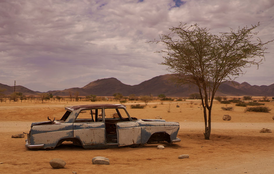
We stopped for refuel and coffee in Solitaire, where we found a typical Wild West petrol station, filled with old cars.
Initially, we wanted to see Deadvlei the same day but the place is 60 km away from Sesriem and it is not recommended to go there too late in the afternoon because the park closes the gates at sunset. We decided to visit Sesriem canyon instead and go to Deadvlei early in the morning.
Since it`s one of the most touristic spots in the whole country, the accommodation/ campsites variety is pretty good. We found some nice places: Sossus Oasis campsite ( but ask for the private one ) and Desert Camp.
We ended up to the second one because we couldn`t find a private campsite for the second night. Desert Camp is actually a lodge and they offer rooms but it looks really nice and remote. Although it is a bit expensive, it`s worth the whole experience as you are surrounded by roaming animals and you have a private bar and pool.
Another campsite which looked nice but didn`t have empty spaces was Sesriem Oshana Camp.
Just to let you know: all of the campsites have swimming pools.

Day 7 – Deadvlei, Sossusvlei, Dune 45 and relax ( 210 km )
This day was the highlight of our trip. We finally managed to wake up before sunrise and did our best to catch the first rays of light on our camera.
The road from Sesriem to Deadvlei is fully tarred ( probably the only one in the area ) but there is a speed limit of 60km/h so it would take about an hour to reach Deadvlei.
Bear in mind, after the tar road ends, there is only sand road and you are not allowed to proceed further unless you have a 4×4. However, in the worst case scenario, you can walk those few kilometers.
We must say that this was the most touristic part of Namibia and the most beautiful, at the same time. And going there early in the morning definitely makes the difference.
We spent 3-4 hrs in Deadvlei taking photos and climbing dunes then we came back to the camp to get some rest and lay a bit in the sun, then we returned in the afternoon for some sunset light on Dune 45.
We must say that it was less crowded in the afternoon. At least, we got Dune 45 only for ourselves. And it was awesome!
P.S: Do you know where the name “Dune 45” comes from?
It is called like this because it lies 45 km from Sesriem ( out of a total of 60 km to Deadvlei )


Day 8 – drive from Sesriem to Luderitz via Aus ( 470 km , 6 hrs )
Quite a long day, as well. We drove for about 5 hrs and a half to Luderitz. On the way, we stopped just after passing Aus to take some pictures of the famous wild horses. We were not sure if we will be able to see them but apparently there are a lot of water holes which keep them in a certain area. There is even an indicator ” Wild Horses”.
If you want to stop for lunch, we recommend Helmeringhausen village. Here, there is a small hotel and campsite which has home made food and drinks : Helmeringhausen Hotel & Gästehaus.
We arrived about 5 pm in Kolmanskop, the ghost town ( 10 km before Luderitz ), just to find out that the opening hours are between 0800- 1300 and you need tickets to enter. We made a quick search on google and we found out that tickets can be bought in the tourist information office in Luderitz. We went there quickly ( at 1800 they were closing ) and found out we can actually buy a special photography permit ( for amateurs photographers only ) which allowed us access from sunrise to sunset ( outside of opening times ). The permit was about 3 times more expensive than the normal ticket but still cheap ( about 15 Euros per person ) and we must say it was worth every penny.

Day 9 – Kolmanskop then return and overnight in Helmeringhausen ( 230 km, 2hrs 30 min )
We woke up early morning to get the first rays of sunlight in Kolmanskop, as this is the best light for photography there. We were literally the only ones in the town.
You can learn more about Kolmanskop in one of National Geographic`s articles here. We also attended the guided tour for half an hour, which, we must say, was interesting.
We headed back to Luderitz to have lunch then drove to Helmeringhausen to spend the night. We camped in the same place we had lunch on the inbound leg, Helmeringhausen Hotel & Gästehaus, and we were the only people in the campsite. Because there was no light pollution at all, we enjoyed the most beautiful sky full of stars ever.

Day 10 – drive from Helmeringhausen back to Windhoek ( 450 km, 5 hrs )
We drove 5 hours to Windhoek straight after breakfast and we had lunch in the capital city. we tried to find a nice restaurant to celebrate our last day in Namibia. We chose Stellenbosch Wine Bar but you can check a bigger list of restaurants on Trip Advisor.
Since we didn`t have a booking for a campsite in Windhoek, we started looking on the spot and we found a really nice one: Urbancamp.net . Although they don`t feature private spots with own bathroom, the location was still nice and cosy, hippie stile, we would say. It was about 2 km away from the city center ( handy for having a walk ) and they had a really delicious and cheap breakfast.
Useful info
Drones
Drones are generally allowed but you must obtain a permit for use prior to entering Namibia. However, they are totally banned in national parks, for the simple fact that poachers use them 😓. There are also certain rules and regulations that need to be followed and which can be found here. The official website of the Namibian Civil Aviation Authority provides more info on how to obtain the permit but we had read on various websites and forums that they are not very responsive.
We can say from our experience that, since Namibia is so remotely inhabited and has so much desert, if you use common sense, don’t bother other people or animals and follow the general rules, you can use your drone every now and then. No one is going to watch you. Don’t use it in the parks, though!
However, Namibia has a lot of desert, and we don`t know if all the deserts are the same, but the sand in this one has significant amounts of magnetite. As the name suggests, magnetite creates magnetic fields around the drone which impair its navigation system, therefore you will get a lot of errors and a lot of times will not be able to fly.
We tried to launch it on few roads and we managed after several compass calibrations. We also tried to use it in Sandwich Harbour but our driver didn’t allow us stating it is clearly forbidden to use it there.
Driving
We posted an article which contains info about driving in Namibia in ” Getting around ” section.
Apart from that, bear in mind that only a few roads are tarred ( eg B1, B4 ). The rest of them are gravel roads and occasionally sand roads. Contrary to our expectations, they are in pretty good shape and you can easily drive 80-90km/h, which is actually the recommendation.
Probably you will be briefed about this by your car rental company, but it is still handy to know that you will need to inflate or deflate your tires depending on the road type as follows:
- tarred road – 2.2 psi
- gravel road – 1.6 psi ( it still works with 1.4 psi )
- sand road – 1.2 psi but we recommend lower, even 0.8 psi – 1.0 psi ( in the morning, on cold tires )
It is recommended, whenever possible, to inflate or deflate in the morning, before the first drive. Deflation of tires basically helps to reduce vibration to the entire car on gravel roads and provides better control on sand and helps you not to get stuck.
It is not reccommended at all to drive at night. ( due to drunk drivers, possible people or animals on the roads etc )
GPS / Google Maps
We entirely used Google Maps for our trip and we must say that it worked pretty well. The distances time estimations are all correct and reliable.
SIM card
There are only two cell service providers in Namibia. MTC and TN Mobile have very similar prices, but MTC has better coverage, which made the decision about which one to buy pretty straightforward. It costed us about 500 N$ for 10 days.
Bear in mind, though, that in some areas you will need to download your maps before hand because there is poor or no coverage. These areas are: some parts of Etosha, Namibia Naukluft park, Sesriem and some areas in between.
Sandwich Harbour tour
As mentioned before, we really recommend not to try to do this drive yourself as it is more dangerous than you imagine. Not that you can loose your life, but you can definitely loose your rented car and many money from your pocket. Full info in ” Day 5 ” section.
What we do recommend is the lovely driver we had for our tour. His contact details are John.Tours.wb@gmail.com and +2640818113618 and his name is John Robinson.
What to pack
The weather is generally nice and warm, sometimes too warm. Mornings and evenings can be cooler in some parts and the entire Atlantic coast is really chilly (15 -18 degrees Celsius ). There is dust or sand everywhere.
Therefore, you will mostly need shorts, T-shirts and sneakers most of the time ( avoid sandals due to dust ) and pack some layer clothes for the coast ( long pants, wind stopper and first layer ).
Malaria is not really a problem in Namibia apart from some areas in the north, but we recommend some precautions such as wearing long sleeved clothes at night and in the mornings and use DEET insect repellent . If you are really crazy about it you can get some Malaria self tests online and buy Coartem tablets when you get there.
We did not take any precautionary Malaria treatment.
Himba village
If you have more time than we did, you can try to go visit a more authentic Himba tribe, such as those in the far north, close to the border with Angola.
If you go to Palmwag, there is Palmwag Lodge and Campsite, which offers Himba tours in the north, close to Epupa Falls.
Alternatively, you can go on your own to Epupa Falls and try to find a tour or a guide there. Epupa Camp and Epupa Falls Lodge are just two examples.
What to expect
Like in most life situations, it`s better to expect nothing and do your best. 😊
However, in order to break some myths, we will give some insights.
Namibia is one of the most unique places on Earth and it feels remote, like you just got to another planet. Despite the fact that it is an African country, the few cities are pretty well developed and you can find pretty much everything there. The few roads that are tarred are in a very good condition and the ones which are not tarred don`t pose too many issues. Actually, we found driving here more relaxing and less time consuming than in Europe.
The country was better developed for road trips and camping than we expected. All the camps were very well prepared and had everything you need. Most of them had private spots with private bathroom and shower and all of them had swimming pools. The average price was 30 Euros for two people for a night.
Expect a lot of dust, sand and drought. Expect an amazing photography destination. Expect roaming animals through the campsites. Expect a really unique country!
Next, get inspired by our photo collection, shot entirely with Sony A7III camera and our 3 lenses: Sony 135 mm, Tamron 28-75 mm and Zeiss 55 mm.